-
play_arrow
LIVE Radio The Caribbean Sound

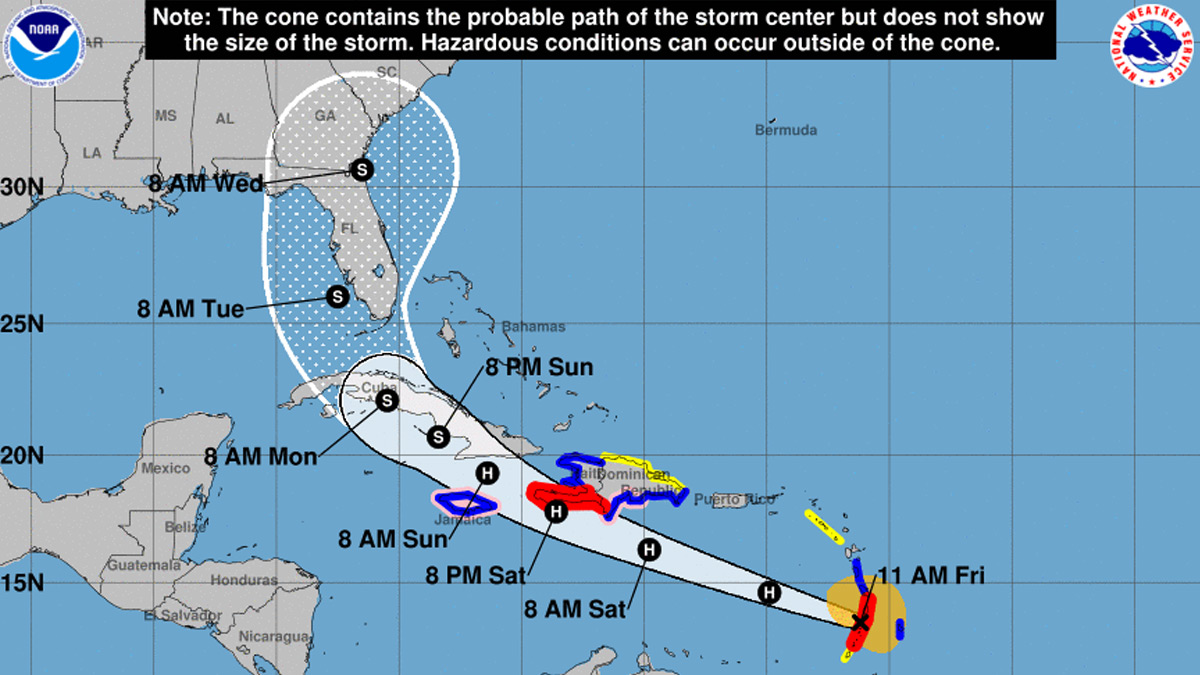
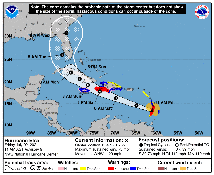
Hurricane Elsa Advisory Number 9 – 1100 AM AST Fri Jul 02 2021
…CENTER OF ELSA PASSING NEAR ST. VINCENT AND ST. LUCIA…
…HURRICANE CONDITIONS SPREADING THROUGH THE WINDWARD ISLANDS…

SUMMARY OF 1100 AM AST…1500 UTC…INFORMATION
———————————————–
LOCATION…13.4N 61.2W
ABOUT 5 MI…10 KM N OF ST. VINCENT
ABOUT 675 MI…1090 KM ESE OF SANTO DOMINGO DOMINICAN REPUBLIC
MAXIMUM SUSTAINED WINDS…75 MPH…120 KM/H
PRESENT MOVEMENT…WNW OR 290 DEGREES AT 29 MPH…46 KM/H
MINIMUM CENTRAL PRESSURE…995 MB…29.39 INCHES
WATCHES AND WARNINGS
——————–
CHANGES WITH THIS ADVISORY:
A Hurricane Warning is now in effect for the southern portion of
Haiti from Port Au Prince to the southern border with the Dominican
Republic.
The Meteorological Service of the Dominican Republic has issued a
Hurricane Watch for the south coast of the Dominican Republic from
Punta Palenque to the border with Haiti, a Tropical Storm Warning
for the south coast from Cabo Engano to the border with Haiti, and
a Tropical Storm Watch for the north coast from Cabo Engano to
Bahia de Manzanillo.
The Government of Jamaica has issued a Hurricane Watch and Tropical
Storm Warning for Jamaica.
SUMMARY OF WATCHES AND WARNINGS IN EFFECT:
A Hurricane Warning is in effect for…
* St. Lucia
* St. Vincent and the Grenadines
* Southern portion of Haiti from Port Au Prince to the southern
border with the Dominican Republic
A Tropical Storm Warning is in effect for…
* Barbados
* Martinique
* Dominica
* The southern coast of Dominican Republic from Cabo Engano to the
border with Haiti
* The coast of Haiti north of Port Au Prince
* Jamaica
A Hurricane Watch is in effect for…
* South coast of the Dominican Republic from Punta Palenque to the
border with Haiti
* Jamaica
A Tropical Storm Watch is in effect for…
* Grenada and its dependencies
* Saba and Sint Eustatius
* North coast of the Dominican Republic from Cabo Engano to
Bahia de Manzanillo
A Hurricane Warning means that hurricane conditions are expected
somewhere within the warning area, in this case in the next few
hours. Preparations to protect life and property should be rushed
to completion.
A Tropical Storm Warning means that tropical storm conditions are
expected somewhere within the warning area.
A Hurricane Watch means that hurricane conditions are possible
within the watch area. A watch is typically issued 48 hours
before the anticipated first occurrence of tropical-storm-force
winds, conditions that make outside preparations difficult or
dangerous.
A Tropical Storm Watch means that tropical storm conditions are
possible within the watch area.
Interests elsewhere in the Windward Islands, Leeward Islands, the
Virgin Islands, Puerto Rico, the Dominican Republic, Cuba, and the
Cayman Islands should monitor the progress of Elsa. Additional
watches and warnings will likely be required later today.
For storm information specific to your area, please monitor
products issued by your national meteorological service.
DISCUSSION AND OUTLOOK
———————-
At 1100 AM AST (1500 UTC), the center of Hurricane Elsa was located
near latitude 13.4 North, longitude 61.2 West. Elsa is moving toward
the west-northwest near 29 mph (46 km/h), and this motion is
expected to continue during the next couple of days, with some
decrease in forward speed expected Sunday night. On the
forecast track, Elsa will move away from the Windward Islands
during the next several hours, move across the eastern Caribbean
Sea later today and tonight, and move near the southern coast of
Hispaniola late Saturday or Saturday night. By Sunday, Elsa
is forecast to move near Jamaica and portions of eastern Cuba, and
move near portions of central and western Cuba Sunday night and
early Monday.
Maximum sustained winds are near 75 mph (120 km/h) with higher
gusts. Little change in strength is forecast during the next 48
hours. Some decrease in winds is possible on Monday as Elsa
interacts with Cuba.
Hurricane-force winds extend outward up to 25 miles (35 km) from the
center and tropical-storm-force winds extend outward up to 140 miles
(220 km). The Hewanorra Airport on St. Lucia recently reported
sustained winds of 46 mph (74 km/h) and a wind gust of 79 mph (127
km/h).
The estimated minimum central pressure is 995 mb (29.39 inches).
HAZARDS AFFECTING LAND
———————-
Key messages for Elsa can be found in the Tropical Cyclone
Discussion under AWIPS header MIATCDAT5, WMO header WTNT45 KNHC and
on the web at
www.hurricanes.gov/graphics_at5.shtml?key_messages.
WIND: Hurricane conditions are expected in the hurricane warning
area in the Windward Islands for the next few hours. Tropical storm
conditions are expected in portions of the Windward and southern
Leeward Islands within the tropical storm warning areas and are
possible in the tropical storm watch areas later today. Hurricane
conditions are expected in the hurricane warning area in Haiti by
late Saturday and are possible in the hurricane watch area in the
Dominican Republic by late Saturday. Hurricane conditions are
possible on Jamaica late Saturday or Sunday.
STORM SURGE: A storm surge will raise water levels by as much as 1
to 3 feet above normal tide levels in areas of onshore winds in the
hurricane warning area in the Windward Islands and 2 to 4 feet
above normal tide levels along the southern coast of Hispaniola.
RAINFALL: Elsa is expected to produce rainfall totals of 4 to 8
inches with maximum amounts of 15 inches today across the Windward
and southern Leeward Islands, including Barbados. This rain may lead
to isolated flash flooding and mudslides.
Over Puerto Rico, rainfall of 1 to 3 inches with localized amounts
of 5 inches is expected late today into Saturday. This rain may lead
to isolated flash flooding and minor river flooding, along with the
potential for mudslides.
Across portions of southern Hispaniola and Jamaica, rainfall of 4 to
8 inches with isolated maximum amounts of 15 inches is possible
Saturday into Sunday. This rain may lead to scattered flash
flooding and mudslides.
SURF: Swells generated by Elsa will spread westward across the
Caribbean Sea during the next few days. These swells are likely to
cause life-threatening surf and rip current conditions. Please
consult products from your local weather office.
NEXT ADVISORY
————-
Next intermediate advisory at 200 PM AST.
Next complete advisory at 500 PM AST.
Written by: Radio Caribbean International
Similar posts
Now On-Air
Contact Information
Office: 1-758-452-2636
ON-AIR: 1-758-452-3046
WhatsApp: 1-758-724-0008______________________________
Office: info@rcistlucia.com
Sales: sales@rcistlucia.com
Newsroom: news@rcistlucia.com
© 2026 Radio Caribbean 1982 Limited. ALL RIGHTS RESERVED


